|
|
|
|
©2008,
| |
| Clarion
Publications, Inc. All rights reserved | |

Stay off my Finger Lakes Trail!
| | If it's emptiness you're after, try Swift Hill or Palmer's Pond in Allegany County.by David EdneyYou say you'd really like to get away for once? Tired of sharing
the lean-to, (and the loo) with every Dick and Jane? I know whatcha mean, pal.
That's why I hesitate to tell you much about the Finger Lakes Trail System. So
far, it's a nicely kept secret. This'll probably blow it, but I'm getting paid
to write this stuff. |
| There's a branch that goes
all the way to Canada, too. The Conservation Trail begins at Lewiston-Queenston
Bridge, goes through Niagara University Campus, and meets the main trail 75 miles
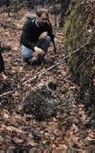
away near Ellicottville. The places I've mentioned so far actually get some traffic, though not nearly as much as you'd think. If it's emptiness you're after, try Swift Hill or Palmer's Pond in Allegany County. Guaranteed, your only companions up there will be deer, turkeys, raccoons, and an occasional lonesome bear. My favorite spot is Rock City State Forest near Ellicottville where apartment-sized boulders are splitting away from an ancient Appalachian mountaintop, making a half square-mile labyrinth of nooks and crannies. Only a couple of miles below Rock City is an abandoned CCC camp that makes for enjoyable exploring. The Finger Lakes Trail hits many such places as it meanders across New York's Southern Tier. The trail system is maintained voluntarily by families and hiking clubs, which usually means the trail is cleared and marked, but that's all. You won't get lost, and there are lean-tos along the way, but if you're looking for picnic tables every mile, forget it. This is real outdoors for real outdoor people. Now, stay off my trail! If you go: The Finger Lakes Trail System is open for hiking year-round. A complete and comprehensive set of trail maps is available by contacting: Finger Lakes Trail Conference, PO Box 18048, Rochester, N.Y. 14618-0048. 585-658-9320. ·Trail access points may be found at major highway crossings, and in parks or other public locations. Look for the foot-square yellow signs with green FLT logo. The main trail is marked with white blazes at frequent intervals. Branch trails, such as those around Letchworth Park are marked with yellow blazes. All this and much more is detailed on the trail maps. www.fingerlakestrail.org Dave Edney lives in Belfast and owns Great Circle Adventures. He describes himself as an explorer of ideas and places. |
According to WebCounter you are the
person to seek the Best of the West!
|